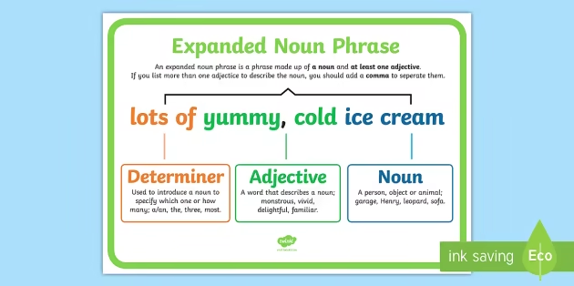
In English grammar, expanded noun phrases are essential tools for creating vivid, descriptive, and precise sentences. They allow writers to add detail, specificity, and richness to their writing, making ideas clearer and more engaging. Unlike simple noun phrases, which consist of a single noun or a determiner plus a noun, expanded noun phrases incorporate modifiers such as adjectives, prepositional phrases, and relative clauses. This added detail enhances the overall quality of both written and spoken communication, allowing writers to convey exact meaning and tone effectively.
The importance of expanded noun phrases cannot be overstated, especially in academic, creative, and professional writing. In essays, reports, or articles, they help communicate complex ideas succinctly while providing necessary context. In creative writing, they paint vivid imagery that immerses the reader in the narrative, making scenes and characters more relatable and lifelike. Everyday communication also benefits from well-crafted expanded noun phrases, as they allow individuals to express ideas with clarity, reducing ambiguity and misunderstanding.
This guide explores the concept of expanded noun phrases in depth. It covers definitions, components, types, structures, usage tips, common mistakes, and exercises for practice. By the end of this article, readers will have a comprehensive understanding of how to construct and use expanded noun phrases effectively in various writing contexts. Whether you are a student, professional, or aspiring writer, mastering expanded noun phrases will elevate the quality, precision, and expressiveness of your writing.
What Are Expanded Noun Phrases?
A noun phrase is a group of words that functions as a noun in a sentence, typically consisting of a noun and its modifiers. A simple noun phrase might include only a determiner and a noun, such as “the book” or “a cat.” While functional, these simple phrases provide minimal information. Expanded noun phrases, on the other hand, extend these basic structures by incorporating additional words or clauses that describe, specify, or contextualize the noun. For instance, “the tall, elegant book with a leather cover on the shelf” provides far more information than “the book.”
Expanded noun phrases are constructed using various elements. Determiners such as “the,” “a,” “this,” or “some” set the scope of the noun. Adjectives describe qualities, characteristics, or attributes, adding richness to the sentence. Prepositional phrases provide context, such as location, time, or cause, while relative clauses offer additional information about the noun, often introduced by words like “which,” “who,” or “that.” By combining these elements thoughtfully, writers can create phrases that are precise, detailed, and engaging.
The key advantage of expanded noun phrases is their ability to convey information efficiently within a single phrase, reducing the need for multiple sentences. For example, “the small, abandoned cottage at the edge of the forest, which had been empty for decades” communicates setting, size, and history in one cohesive phrase. Such phrases not only enhance clarity but also improve sentence flow, making writing more readable and professional.
Types and Structures of Expanded Noun Phrases
Expanded noun phrases can take several forms, depending on the elements used to extend the basic noun phrase. One common technique is using adjectives to add descriptive detail. For example, “the ancient, crumbling castle” immediately conveys both age and condition. Multiple adjectives can be combined to provide richer imagery, but it’s important to maintain logical order and readability.
Another method involves prepositional phrases, which often describe location, time, or relationship. For instance, “the painting on the wall of the grand hall” gives specific context about where the painting is situated. Prepositional phrases are particularly useful in academic or technical writing, where context and precision are essential. They can also enhance narrative writing by creating vivid mental images for readers.
Relative clauses are another way to expand noun phrases, offering additional information about the noun. For example, “the student who scored highest on the exam” provides more context than simply “the student.” Relative clauses can describe people, objects, or abstract concepts, adding depth without requiring multiple sentences. Combining adjectives, prepositional phrases, and relative clauses allows for highly descriptive and complex noun phrases.
Writers must balance complexity with readability. Overloading a noun phrase with too many modifiers can overwhelm the reader, while too few may leave the description vague. Understanding how to structure expanded noun phrases effectively enables writers to communicate detailed information clearly, keeping sentences both engaging and easy to read.
How to Use Expanded Noun Phrases in Writing
Expanded noun phrases are versatile tools used across various writing styles. In academic writing, they enhance clarity and precision by providing context and specificity. For example, “the statistical analysis of the recent survey results conducted by the university” is more informative than “the analysis.” Using expanded noun phrases allows scholars to convey complex ideas succinctly while maintaining professionalism.
In creative writing, expanded noun phrases bring narratives to life. Descriptive phrases like “the golden-haired child with sparkling eyes and a mischievous smile” immerse readers in the scene and deepen character development. Writers can use these phrases to set the atmosphere, describe settings, and build tension or emotion without relying on multiple sentences. This technique is particularly effective in short stories, novels, and poetry.
Even in everyday writing, such as emails, reports, or informal communication, expanded noun phrases improve clarity and reduce ambiguity. Instead of saying, “I sent the document,” one might write, “I sent the updated document with the revised financial figures to the management team.” This level of detail helps convey the message accurately, preventing misunderstandings and improving professionalism.
To use expanded noun phrases effectively, writers should vary sentence structure, avoid repetitive patterns, and ensure modifiers enhance rather than clutter the sentence. By practicing these techniques, writers can craft sentences that are informative, engaging, and stylistically polished.
Common Mistakes and How to Avoid Them

While expanded noun phrases improve writing, they can also introduce common pitfalls if used improperly. One frequent mistake is overloading sentences with too many modifiers, making them difficult to read. For example, “the large, ancient, crumbling, ivy-covered, shadowy castle on the hill overlooking the village” might overwhelm readers. Writers should prioritize essential details and distribute information across sentences when necessary.
Misplacing adjectives or prepositional phrases is another common error, which can alter meaning or create ambiguity. Proper placement ensures modifiers clearly relate to the intended noun. For instance, “the man with the hat walking his dog” is clearer than “the man walking his dog with the hat,” which might confuse readers.
Using unnecessary complexity can also reduce readability. While expanded noun phrases add detail, overly long or convoluted phrases can make sentences awkward. Writers should aim for balance, using modifiers strategically to enhance clarity rather than hinder it.
Strategies for avoiding mistakes include reviewing sentence flow, reading aloud to check readability, and practicing incremental expansion of noun phrases. By carefully constructing expanded noun phrases, writers can maintain clarity while enriching their writing with descriptive detail.
Exercises and Practice Activities
Practicing expanded noun phrases is essential for mastery. One exercise is identifying expanded noun phrases in sample sentences and analyzing their structure. For example, in “the bright, golden sun shining over the quiet village,” students can identify the adjectives and prepositional phrase that expand the noun.
Another activity involves expanding simple noun phrases using adjectives, prepositional phrases, and relative clauses. For instance, turning “the dog” into “the small, playful dog with curly fur that chased the ball” helps learners practice combining elements effectively.
Writing descriptive paragraphs using multiple expanded noun phrases encourages practical application. For example, describing a setting or character in detail strengthens both creative and analytical writing skills. Self-assessment involves checking for clarity, flow, and readability, ensuring each expanded noun phrase enhances the text without overwhelming it.
Consistent practice helps writers internalize patterns, understand when and how to use modifiers, and develop confidence in creating engaging, detailed sentences.
Conclusion
Expanded noun phrases are invaluable tools for enhancing English writing. They allow writers to add detail, specificity, and clarity to their sentences, making communication more precise and engaging. By understanding their structure, types, and proper usage, writers can improve both academic and creative writing. Regular practice, careful placement of modifiers, and attention to readability ensure expanded noun phrases are effective and impactful. Mastering these phrases elevates writing, making it descriptive, professional, and memorable.
Frequently Asked Questions (FAQs)
What is the difference between a noun phrase and an expanded noun phrase?
A noun phrase consists of a noun and its basic components, while an expanded noun phrase includes additional modifiers such as adjectives, prepositional phrases, or relative clauses.
Can expanded noun phrases be too long?
Yes, excessively long phrases can overwhelm readers. Balance detail with clarity for best results.
How do expanded noun phrases improve writing?
They provide specificity, context, and vivid descriptions, enhancing both clarity and engagement.
Are expanded noun phrases used differently in creative and academic writing?
Yes. Creative writing uses them for imagery and character detail, while academic writing focuses on precision and clarity.
Can a prepositional phrase always expand a noun phrase?
Generally, yes, as prepositional phrases add context like location, time, or relationship.
How can beginners practice using expanded noun phrases effectively?
Start with simple adjectives and prepositional phrases, then gradually incorporate relative clauses and more complex structures.
Do expanded noun phrases affect sentence readability?
They can, if overused or poorly structured. Clear placement and moderation ensure readability.
What are some common examples of expanded noun phrases?
Examples include “the small, abandoned cottage on the hill” or “the bright, shining star that guided the travelers.”
You May Also Read: Christmas Nails