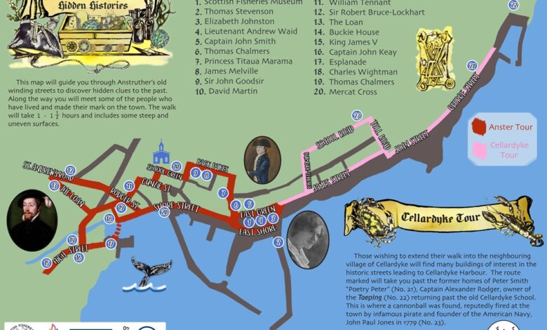
Map of Anstruther Fife Nestled along Scotland’s picturesque East Neuk coastline, Anstruther is a charming fishing town in Fife that draws thousands of visitors each year. Known for its bustling harbour, award-winning fish and chips, and stunning coastal scenery, it’s no surprise that travelers want to explore every corner of this seaside gem. Whether you are visiting for a day trip or staying longer to soak up its maritime history, having a map of Anstruther Fife can make your journey far more rewarding.
Maps are more than just navigation tools; they are gateways to discovery. A well-detailed map not only shows you where you are but also highlights the cultural landmarks, hidden alleys, and nearby villages that might otherwise go unnoticed. In this guide, we will explore why maps are essential for understanding Anstruther, how to use them for sightseeing, and where to access both digital and printable versions. By the end, you’ll be fully equipped to uncover all the beauty this Fife treasure has to offer.
Understanding Anstruther, Fife
Location and Historical Background
Anstruther sits on the eastern coast of Scotland, in the council area of Fife, about 9 miles from St. Andrews. It is part of a string of small towns and villages known collectively as the East Neuk of Fife. Once a thriving hub for fishing, particularly herring, Anstruther has retained much of its maritime heritage, which is evident in its narrow cobbled streets and historic waterfront buildings. A map of Anstruther helps put this history into context, pinpointing the exact places where trade and fishing once dominated daily life.
Over the centuries, Anstruther developed into more than just a fishing port. The town became home to the Scottish Fisheries Museum, which sits proudly on the harbour and offers a deep dive into the area’s rich heritage. With a map in hand, visitors can trace the evolution of Anstruther from a medieval settlement into a modern-day tourist favourite. By visualising its geography, one can appreciate how its location on the Firth of Forth played a role in shaping its economic and cultural development.
Why Visitors Use Maps of Anstruther
For first-time visitors, Anstruther may seem small, but its charm lies in the details. Maps are particularly useful in navigating its maze-like streets, where every corner could reveal a hidden garden, a centuries-old church, or a locally owned boutique. By studying a map before setting out, travelers can plan their walking routes to ensure they don’t miss key highlights like the harbourfront or the quaint fishing quarter.
Additionally, maps are indispensable for those who wish to understand the broader East Neuk region. They highlight how closely Anstruther is connected to neighbouring villages such as Cellardyke and Pittenweem. Many visitors combine their trip to Anstruther with a scenic coastal walk, and maps make it easy to calculate distances, plot rest stops, and choose the best viewpoints. In short, a map of Anstruther Fife transforms casual wandering into a structured adventure.
Exploring the Map of Anstruther Fife
Key Landmarks and Attractions
When looking at a map of Anstruther, the first point that usually stands out is its picturesque harbour. This bustling centrepiece is lined with colourful boats, seafood restaurants, and traditional stone houses. The harbour area is also where you’ll find the Scottish Fisheries Museum, one of the town’s most visited attractions. With a map, visitors can easily identify nearby historical sites, such as the Dreel Tavern, a 17th-century coaching inn, and the local parish churches.
Maps also highlight cultural touchpoints that may not immediately catch the eye. For example, tucked away in small lanes are art galleries, craft shops, and heritage plaques marking significant historical events. A map allows you to structure your day so you don’t miss these details, ensuring your visit is both educational and enjoyable.
Natural Features and Coastal Routes
Beyond the man-made attractions, Anstruther’s natural beauty is equally captivating. A map shows how the town hugs the Fife coastline, opening opportunities for scenic walks along the Fife Coastal Path, which stretches for over 100 miles. Walking this route from Anstruther offers stunning views of the North Sea, rugged cliffs, and sandy coves.
Maps are invaluable here because they highlight where footpaths intersect with roads, car parks, and points of interest such as bird-watching spots. Many visitors use maps to find quieter areas for a peaceful stroll, away from the bustling harbour. This combination of human history and natural scenery makes the map of Anstruther Fife a vital companion for exploration.
Neighbouring Villages on the Map
One of the greatest advantages of consulting a map is realising how close Anstruther is to other East Neuk villages. Just a short walk eastward brings you to Cellardyke, known for its historic wynds and traditional fishing cottages. A little further along lies Pittenweem, a charming town famous for its art festival and working harbour. To the west, maps reveal Crail, with its photogenic harbour and medieval charm.
By using a map, visitors can create their own multi-village itineraries. These routes often combine history, culture, and outdoor activities, making a simple trip to Anstruther a gateway to discovering the entire East Neuk.
Practical Uses of the Map
Tourist Planning
For tourists, a map serves as the perfect planning tool. Many visitors use it to design walking tours that cover the main highlights in a single day, including the harbour, Fisheries Museum, and the Fife Coastal Path. Maps also make it easy to spot cafés and restaurants along the route, ensuring that a break for Anstruther’s world-famous fish and chips is never missed.
Beyond sightseeing, maps help tourists decide where to spend more time. Some prefer cultural experiences, while others may focus on outdoor activities like coastal hikes. By marking locations in advance, maps help travellers balance their itinerary for a more fulfilling visit.
Local Amenities
Another practical use for maps is identifying amenities. Anstruther offers a variety of eateries, from casual cafés to traditional pubs, many of which are mapped out clearly in tourist guides. Shoppers can use maps to locate local markets and boutique stores, while those planning overnight stays can quickly find hotels, guesthouses, or B&Bs.
For families, maps also show the locations of playgrounds, public toilets, and picnic spots. Knowing these in advance ensures a stress-free trip, particularly when travelling with children or larger groups.
Transport and Accessibility
Transport information is another valuable feature of maps. Many maps of Anstruther show bus routes, linking the town to St. Andrews and other parts of Fife. Car parks are also clearly marked, which is especially helpful during peak tourist seasons when spaces are limited.
Cyclists benefit greatly from maps too, as they can plan routes along the coastal path or through quieter inland roads. Accessibility details, such as wheelchair-friendly paths, are often included on modern maps, making Anstruther a destination open to everyone.
Digital and Printable Maps of Anstruther
Online Map Resources
Today, the easiest way to find your way around Anstruther is through online maps like Google Maps. These platforms not only show streets and landmarks but also offer Street View, allowing visitors to preview their routes virtually. Online tourism websites dedicated to Fife also provide interactive maps tailored to tourists, with attractions highlighted for convenience.
Printable Maps for Tourists
For those who prefer a traditional approach, printable maps are widely available. Many visitor centres in Anstruther and the surrounding region provide free handouts. These paper maps are perfect for travellers who want a tactile, easy-to-read reference without relying on internet connections or mobile data.
Interactive Maps for Mobile Devices
Mobile apps take navigation to another level by offering GPS-enabled maps. These allow users to track their location in real time, making it almost impossible to get lost. Some apps even feature augmented reality, pointing out attractions as you walk through the town. For tech-savvy travellers, these interactive maps are the ultimate tool for exploring Anstruther.
Conclusion
A map of Anstruther Fife is more than a navigational aid; it is a key that unlocks the rich history, culture, and natural beauty of this seaside town. Whether you’re exploring the harbour, tracing the Fife Coastal Path, or planning day trips to neighbouring villages, a reliable map ensures you don’t miss a thing. From digital tools to printable guides, the options are plentiful, making it easier than ever to experience Anstruther to the fullest. With a map in hand, every corner of this East Neuk treasure is yours to discover.
FAQs About Map of Anstruther Fife
Where can I find a free map of Anstruther Fife?
Free maps are available at the local visitor centre, tourism websites, and as printable PDFs online.
What are the must-see attractions shown on the map?
Highlights include the harbour, Scottish Fisheries Museum, coastal path, and nearby villages such as Cellardyke and Pittenweem.
Can I walk between Anstruther and nearby villages using the map?
Yes, the Fife Coastal Path makes walking between neighbouring villages easy and enjoyable.
Are there digital maps available for mobile use?
Yes, Google Maps and mobile apps provide real-time navigation and interactive features.
Does the map show public transport routes around Anstruther?
Many tourist maps include bus routes and stops, along with car parks and cycle-friendly paths.
What is the best map for exploring the Fife Coastal Path from Anstruther?
A detailed walking map, available from visitor centres and online hiking resources, is recommended for coastal exploration.
You May Also Read: Cadbury Recall