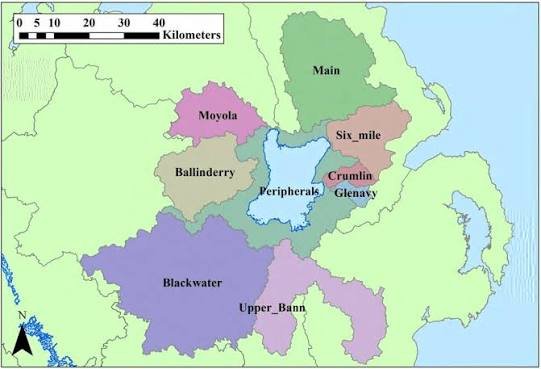
A Lough Neagh Ireland Map shows the exact position of Northern Ireland’s largest freshwater lake, its surrounding counties, nearby towns, travel routes, and important landmarks. Located almost at the centre of Northern Ireland, Lough Neagh is one of the most significant geographical features on the island of Ireland. Covering approximately 383 square kilometres, it is the largest lake in the British Isles and an important natural, cultural, and economic landmark.
For visitors, a detailed map of Lough Neagh Ireland provides a clear understanding of how the lake connects different areas of Northern Ireland. The lake is surrounded by five counties: Antrim, Armagh, Tyrone, Londonderry, and Down. Its central location makes it easily accessible from major cities such as Belfast and Derry, while the surrounding countryside offers opportunities for nature walks, cycling, fishing, photography, and cultural exploration.
A Lough Neagh map is useful not only for tourists but also for students, researchers, and geography enthusiasts. It helps explain the lake’s position, surrounding landscapes, river systems, and nearby communities. Whether someone is planning a trip or simply learning about Northern Ireland’s geography, understanding the location of Lough Neagh provides valuable insight into the region.
Lough Neagh Map With Counties, Towns, and Surrounding Areas
A detailed Lough Neagh Ireland Map highlights the counties, villages, and towns that surround this large freshwater lake. Because Lough Neagh sits in the centre of Northern Ireland, several counties share a connection with its shoreline and surrounding waterways. County Antrim covers much of the eastern and northern side, while County Armagh is located toward the south. County Tyrone stretches along the western area, with Londonderry and Down also forming part of the wider lake region.
The towns around Lough Neagh act as important access points for visitors. Antrim, located on the northeastern shore, is one of the most popular starting points because of its parks, gardens, and connection to the lake. Toome, Ballyronan, Lurgan, Craigavon, and Magherafelt are also important locations shown on many regional maps because they provide access to attractions, walking routes, marinas, and local services.
When using a Lough Neagh counties map, visitors can better understand distances between locations and plan their journey efficiently. The map reveals how communities have developed around the lake and how roads, rivers, and natural areas connect throughout the region.
Lough Neagh Coordinates and Physical Features on the Map
The geographical coordinates of Lough Neagh are approximately 54.6° N latitude and 6.4° W longitude. These coordinates help users locate the lake accurately through digital mapping tools such as Google Maps, satellite imagery, and GPS navigation systems. A satellite view of Lough Neagh clearly shows its large size, distinctive shape, and surrounding countryside.
The lake stretches roughly 30 kilometres from north to south and around 21 kilometres from east to west. Despite its impressive size, Lough Neagh is relatively shallow compared with many other large lakes, with an average depth of around nine metres. Several rivers flow into the lake, including the Blackwater River, Ballinderry River, and Moyola River, while the Lower Bann River carries water away toward the Atlantic Ocean.
A physical map of Lough Neagh also shows important islands within the lake, including Coney Island and Ram’s Island. These locations have historical and ecological importance, offering visitors opportunities to explore wildlife, heritage, and natural landscapes. Understanding these physical features helps explain why Lough Neagh remains such an important part of Northern Ireland’s geography.
How to Find Lough Neagh Ireland Map Using Google Maps and Digital Tools
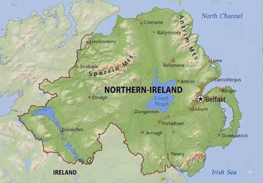
Modern technology has made exploring Lough Neagh easier than ever. Searching “Lough Neagh Ireland Map” on Google Maps provides users with satellite views, road information, nearby attractions, and navigation options. Digital maps allow visitors to check travel times, locate viewpoints, and plan routes before arriving.
Google Maps and other navigation platforms are especially useful because Lough Neagh covers a large area with many different access points. Instead of searching for one single destination, visitors can choose specific locations such as Antrim, Oxford Island, Ballyronan Marina, or Toome depending on their interests. This makes digital mapping an essential tool for exploring the lake.
Offline maps can also be helpful for visitors travelling through rural areas where mobile signals may be weaker. Downloading map information before travelling allows tourists to navigate walking routes, countryside roads, and attractions without depending completely on internet access.
Best Routes Around Lough Neagh Ireland Map for Visitors
A Lough Neagh Ireland Map is extremely useful for planning scenic routes around the lake. Because the shoreline stretches across multiple counties, visitors can create different journeys depending on the amount of time available. A complete drive around the lake allows travellers to experience changing landscapes, historic villages, nature reserves, and waterfront views.
Visitors travelling from Belfast can reach the eastern side of Lough Neagh through Antrim, which offers easy access to lake viewpoints and nearby attractions. The southern area near Oxford Island provides nature trails and birdwatching opportunities, while the western side near Ballyronan and Toome offers traditional fishing communities and peaceful countryside scenery.
Cyclists and walkers can also use a Lough Neagh route map to discover paths around the shoreline. Planning routes in advance helps visitors choose suitable distances, identify rest areas, and find locations with the best views. A map transforms a simple visit into a more organised and enjoyable experience.
Attractions and Places to Visit on a Lough Neagh Map
A detailed Lough Neagh attractions map helps visitors discover the many places surrounding the lake. One of the most popular locations is Oxford Island Nature Reserve, located on the southern shore. The reserve offers walking trails, wildlife observation areas, and views across the lake, making it a favourite destination for nature lovers and photographers.
The Lough Neagh Discovery Centre near Antrim is another important location shown on visitor maps. It provides information about the lake’s environment, wildlife, and cultural history. Nearby attractions such as Antrim Castle Gardens allow visitors to combine a lake trip with historical exploration.
Ballyronan Marina is another key location for visitors interested in boating, family activities, and waterfront walks. Toome is known for its traditional eel fishing heritage and provides insight into the communities that have depended on the lake for generations. Using a Lough Neagh visitor map makes it easier to discover these attractions without missing important locations.
Printable Lough Neagh Ireland Map and Travel Resources
Many visitors searching for a Lough Neagh Ireland Map are looking for printable or offline resources that can help during their journey. A printable map can be useful for road trips, walking adventures, educational projects, and travel planning. Physical maps allow visitors to mark locations, create routes, and keep a simple overview of the lake area.
Tourist maps often include important information such as attractions, walking paths, viewpoints, parking areas, and nearby facilities. Combining a printable map with digital navigation creates a more complete travel experience because visitors can use online tools for accuracy while keeping a physical reference for planning.
For students and geography researchers, maps of Lough Neagh provide valuable information about land use, waterways, settlements, and environmental zones. The lake’s unique position makes it an excellent example of how geography influences communities, ecosystems, and regional development.
Environmental Importance of Lough Neagh Shown on the Map
A Lough Neagh Ireland Map also reveals the environmental importance of the surrounding landscape. The lake supports a wide range of wildlife, including migratory birds, freshwater species, and wetland habitats. Areas around the shoreline provide important ecosystems that contribute to biodiversity throughout Northern Ireland.
Lough Neagh is also significant because it supplies drinking water and supports traditional industries such as eel fishing. The famous Lough Neagh eel fishery has been part of local heritage for centuries, connecting communities with the lake’s natural resources.
However, the lake faces environmental challenges, including water quality concerns, pollution, and changes to aquatic ecosystems. Conservation groups and local communities continue working to protect the lake through monitoring, restoration projects, and sustainable tourism. Maps showing protected areas help visitors understand where conservation efforts are focused.
History and Cultural Importance of Lough Neagh Maps
Historical maps of Lough Neagh provide valuable information about how the landscape and surrounding communities have changed over time. Early maps documented settlements, waterways, and transportation routes, helping historians understand the development of the region.
The lake also holds an important place in Irish folklore. According to legend, Lough Neagh was created by the giant Finn McCool, who supposedly removed a piece of land and threw it toward Scotland. While this story belongs to mythology, it demonstrates the cultural significance of the lake throughout generations.
Today, modern mapping technology combines historical knowledge with satellite imagery and geographic information systems. These resources allow people to explore both the physical landscape and the cultural stories connected with Lough Neagh.
Conclusion
The Lough Neagh Ireland Map is more than a navigation tool; it is a guide to understanding one of Northern Ireland’s most important natural landmarks. From its central location and surrounding counties to its attractions, routes, wildlife, and cultural history, the map reveals the many features that make Lough Neagh unique.
Whether you are planning a road trip, exploring nature, studying geography, or discovering Northern Ireland’s heritage, a detailed Lough Neagh map provides valuable information. Its combination of natural beauty, historical importance, and community connections makes it one of the most fascinating locations on the island of Ireland.
FAQs
Where is Lough Neagh located on the Ireland map?
Lough Neagh is located in central Northern Ireland and is surrounded by the counties of Antrim, Armagh, Tyrone, Londonderry, and Down.
What does a Lough Neagh Ireland Map show?
A Lough Neagh Ireland Map shows the lake’s location, surrounding counties, nearby towns, attractions, roads, waterways, and travel routes.
How can I find Lough Neagh on Google Maps?
You can search “Lough Neagh” or “Lough Neagh Ireland Map” on Google Maps to view its exact location, satellite images, nearby attractions, and directions.
What towns are near Lough Neagh?
Popular towns near Lough Neagh include Antrim, Toome, Ballyronan, Lurgan, Craigavon, and Magherafelt.
How big is Lough Neagh?
Lough Neagh covers approximately 383 square kilometres, making it the largest freshwater lake in the British Isles.
What are the best places to visit around Lough Neagh?
Popular attractions include Oxford Island Nature Reserve, Lough Neagh Discovery Centre, Ballyronan Marina, Antrim Castle Gardens, and Toome.
Can I use a printable Lough Neagh map for travel?
Yes, printable maps can help visitors plan routes, identify attractions, and navigate the lake area alongside digital mapping tools.
You May Also Read: Jokes Against Men