Nestled in the heart of West Yorkshire, Mirfield is a charming market town that blends rich history with modern convenience. For residents and visitors alike, the Mirfield Yorkshire map is more than just a navigation tool—it is a gateway to discovering the character, culture, and charm of this unique town. Whether you are exploring its scenic countryside, delving into historical landmarks, or simply navigating its busy town centre, a detailed map can make the experience more engaging and meaningful.
Mirfield may not be as large as nearby Leeds or Huddersfield, but it holds its own as a town filled with cultural depth, natural beauty, and excellent transport connections. Its location along the River Calder gives it both geographical significance and picturesque landscapes, while the town’s central position in West Yorkshire makes it easy to access by rail, road, or canal. A good map allows you to see how everything connects—from historical buildings to scenic trails—helping you plan your trip with confidence.
This guide will explore the Mirfield Yorkshire map in detail, covering geography, landmarks, transport, attractions, and practical uses for residents and tourists. By the end, you’ll see how a single map can open up countless opportunities for exploration and appreciation of this vibrant Yorkshire town.
Understanding Mirfield’s Geography
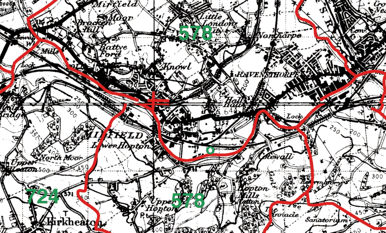
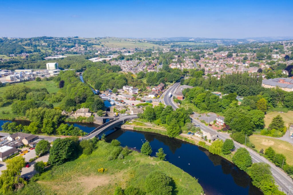
Mirfield is strategically located between Huddersfield, Dewsbury, and Leeds, making it part of West Yorkshire’s wider urban network. When looking at the Mirfield Yorkshire map, one of the first things that stands out is the town’s relationship with water. The River Calder flows through Mirfield, accompanied by the Calder and Hebble Navigation canal, which historically contributed to trade and development. Today, these waterways offer scenic walks and cycling paths, attracting both locals and visitors seeking tranquility.
The town’s layout reflects a balance of urban convenience and rural charm. The central hub is home to shops, eateries, and services, while surrounding neighbourhoods feature residential streets and schools. Beyond the town centre, maps reveal green spaces, woodlands, and farmland that add to Mirfield’s appeal as a place where countryside and town life coexist seamlessly.
Transport networks are also easy to trace on the map. The A644 road runs through the town, connecting it to nearby Dewsbury and Brighouse, while the M62 motorway provides quick access to Leeds and Manchester. Rail links are equally important, with Mirfield Railway Station serving as a key commuter hub for those working in larger cities.
Understanding this geography through a map gives visitors an appreciation of why Mirfield thrives as both a commuter town and a cultural destination. It highlights not just locations but relationships—how rivers, roads, and railways have shaped the town’s identity over centuries.
Key Features on the Mirfield Yorkshire Map
The Mirfield Yorkshire map is dotted with features that highlight the town’s historical, cultural, and natural significance. One of the central areas marked is the town centre, where shops, supermarkets, independent cafés, and pubs bring daily life into focus. This bustling core reflects the town’s balance between tradition and modernity.
Historical landmarks are prominently featured, with St Mary’s Church being one of the most recognisable. Dating back centuries, it is a focal point for both religious and architectural interest. Another key site is the Mirfield Monastery, known for its peaceful setting and spiritual heritage, attracting visitors seeking both history and reflection. The town’s war memorials also serve as important cultural markers, often highlighted on maps as points of remembrance.
Green spaces and natural features are equally important. Maps of Mirfield clearly show the open fields, parks, and the canal system. Areas such as the Calder Valley Greenway provide pathways for walking and cycling, making them essential for both leisure and commuting. These routes link Mirfield to neighbouring towns while offering some of the most picturesque scenery in the region.
Transport hubs are also clearly visible on the map, with Mirfield Railway Station standing out as a major connector to cities like Leeds, Manchester, and Huddersfield. Bus routes and road systems ensure that locals and visitors can navigate the town with ease, making it an accessible and welcoming place for all.
Navigating Mirfield: Roads, Routes, and Travel Tips
For anyone using the Mirfield Yorkshire map, roads and routes are essential features that make travel smooth and efficient. The A644 and A62 roads link the town directly to Huddersfield, Dewsbury, and the motorway network. For those travelling longer distances, the nearby M62 is a vital artery, connecting West Yorkshire to both the east and west coasts of England.
Rail travel is equally important in Mirfield. The railway station, prominently marked on maps, is a lifeline for commuters heading to Leeds, Manchester, or Sheffield. With regular services, it provides a convenient alternative to driving, especially for those who prefer to avoid congestion. Bus routes, which weave throughout the town and connect nearby villages, are also detailed on most maps, giving residents and visitors multiple transport options.
Beyond roads and railways, walking and cycling routes add another layer of navigation. The Calder Valley Greenway, a traffic-free path that follows old railway lines and canal routes, is highlighted on local maps and offers an excellent way to explore both Mirfield and its surrounding landscapes. Cyclists, in particular, find these maps invaluable for planning safe and scenic journeys.
For visitors, travel tips are straightforward: carry a paper map if you plan to walk or cycle, as mobile signals can sometimes be unreliable in rural areas. For drivers, digital maps offer real-time traffic updates, helping to avoid busy spots during peak hours. A good combination of both ensures that navigating Mirfield is a smooth and enjoyable experience.
Exploring Attractions with the Mirfield Yorkshire Map
Using the Mirfield Yorkshire map opens up a wide variety of attractions and experiences. For history enthusiasts, landmarks such as St Mary’s Church and the Mirfield Monastery provide deep insights into the town’s heritage. Their locations are easily found on maps, making them must-visit spots for those exploring the cultural side of Mirfield.
Recreational areas also stand out. Parks, playing fields, and the canal-side walks offer opportunities for relaxation and leisure. The Calder Valley Greenway is especially popular for family outings, dog walks, and cycling trips. With a map in hand, it’s easy to plot routes that connect natural beauty with convenient town access points.
Events and festivals also make use of mapped locations. From community fairs to cultural celebrations, knowing where venues are situated helps visitors plan their day. Whether it’s a concert in the park or a food festival in the town centre, maps provide clarity and prevent missed opportunities.
For those with time to venture further, Mirfield’s map also highlights its proximity to nearby towns and attractions. Dewsbury, Huddersfield, and Brighouse are all within easy reach, each offering additional cultural and shopping experiences. By using a map as a guide, visitors can expand their itinerary beyond Mirfield while still returning to its welcoming charm.
Practical Uses of the Mirfield Yorkshire Map
While visitors use the Mirfield Yorkshire map for exploration, residents rely on it for practical, everyday purposes. Schools, healthcare centres, and community facilities are clearly marked, making it easier for families and newcomers to locate essential services. This practical function ensures that maps are as valuable to locals as they are to tourists.
For tourists, maps serve as itinerary planners. From identifying hotels and B&Bs to locating nearby restaurants, a map helps streamline travel plans. It ensures that visitors can maximise their time, experiencing both the highlights and hidden gems of Mirfield.
Outdoor enthusiasts benefit from maps when planning hiking and cycling routes. Paper maps often offer more detailed topography, allowing walkers to understand gradients, terrain, and footpath connections. For this reason, many prefer traditional Ordnance Survey maps over digital navigation apps when exploring Mirfield’s countryside.
Both digital and paper maps have their advantages. Digital maps provide real-time updates, GPS tracking, and interactive features, making them useful for on-the-go navigation. Paper maps, on the other hand, do not rely on signal strength or battery life and often include finer details of rural paths. Combining the two offers the best of both worlds for anyone navigating Mirfield.
Conclusion
The Mirfield Yorkshire map is more than just a collection of lines and symbols—it is a key to understanding and appreciating the town’s character. From its geography shaped by rivers and canals to its historical landmarks, transport routes, and cultural attractions, the map reveals how Mirfield connects the past with the present.
For residents, maps provide practical guidance in daily life, from finding schools to planning commutes. For visitors, they open doors to history, leisure, and adventure, ensuring that no hidden gem goes unnoticed. Whether digital or paper, a map transforms exploration into a rewarding journey.
As Mirfield continues to grow as part of West Yorkshire’s vibrant landscape, its maps will remain essential tools for connecting people, places, and experiences.
FAQs About Mirfield Yorkshire Map
Where is Mirfield located in West Yorkshire?
Mirfield lies between Huddersfield, Leeds, and Dewsbury, along the River Calder and the Calder and Hebble Navigation canal.
What landmarks should I look for on a Mirfield Yorkshire map?
Key landmarks include St Mary’s Church, Mirfield Monastery, the town centre, and canal routes.
Can I find walking and cycling routes on a Mirfield map?
Yes, routes like the Calder Valley Greenway and canal-side paths are often highlighted.
How can tourists use a Mirfield Yorkshire map?
Visitors can use it to plan itineraries, locate attractions, book accommodation, and navigate services.
Are digital maps better than paper maps for Mirfield?
Digital maps are useful for live updates and GPS, while paper maps are reliable for hiking and detailed rural exploration.
You May Also Read: Google Manchester Office