Map of South Ayrshire Scotland: Your Complete Guide to Towns, Attractions, and Travel Planning

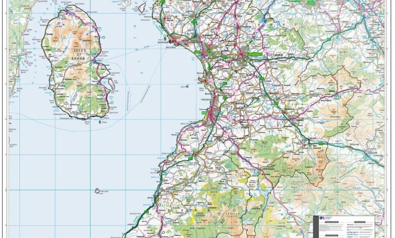
Planning a visit becomes much easier when you have a reliable map of South Ayrshire Scotland. Whether you are exploring the region’s coastline, visiting historic landmarks, discovering quiet villages, or organising a scenic road trip, a well-designed map helps you understand how everything connects. Instead of simply showing roads and place names, it allows travellers to identify nearby attractions, estimate travel times, and build an itinerary that suits their interests. For first-time visitors and returning travellers alike, understanding the area’s layout is one of the best ways to make the most of every journey.
South Ayrshire combines dramatic coastal scenery with historic towns, peaceful countryside, and cultural landmarks that reflect Scotland’s rich heritage. From the lively streets of Ayr to the picturesque harbour at Girvan, every destination offers something different. This guide explains how to use a map effectively while introducing the region’s major towns, transport links, and visitor highlights. Whether you prefer a printed tourist map, an interactive digital map, or a detailed road map, knowing what each option offers will help you travel with greater confidence and discover places that might otherwise be overlooked.
Understanding South Ayrshire Through Its Map
South Ayrshire is located on Scotland’s southwest coast and forms one of the country’s thirty-two council areas. Looking at a map gives an immediate understanding of its varied landscape, with the Firth of Clyde stretching along the western shoreline while rolling farmland, rivers, woodlands, and small rural communities extend inland. The region borders East Ayrshire and Dumfries and Galloway, making it an ideal destination for travellers exploring several parts of southwest Scotland. A detailed map clearly shows these boundaries, helping visitors understand where South Ayrshire begins, how its towns are connected, and which routes provide the easiest access.
Maps also reveal the diversity of the region beyond its administrative borders. Coastal resorts, historic market towns, traditional villages, nature reserves, and scenic viewpoints are all spread across South Ayrshire, creating opportunities for a wide variety of trips. By viewing the area as a whole rather than focusing on a single destination, visitors can identify nearby attractions that fit naturally into their itinerary. Understanding the geographical layout before travelling often leads to better planning, shorter driving times, and a more enjoyable experience throughout the region.
Choosing the Right Map of South Ayrshire Scotland
Not every map is designed for the same purpose, so selecting the right one depends on how you intend to explore South Ayrshire. Tourist maps focus on visitor attractions, heritage sites, beaches, parks, museums, and cultural landmarks, making them ideal for sightseeing holidays. These maps usually include symbols for parking areas, visitor centres, walking routes, public facilities, and popular places of interest. For travellers visiting the area for the first time, they provide a clear overview that simplifies planning and helps ensure that important attractions are not missed.
Road maps, digital navigation services, and detailed topographic maps each provide different advantages. Road maps concentrate on highways, local roads, and driving distances, making them useful for self-drive holidays across the region. Digital maps offer real-time navigation, traffic information, and route adjustments that help drivers and pedestrians reach their destinations efficiently. Meanwhile, topographic maps display terrain, elevation, and countryside paths that are especially valuable for walkers, cyclists, and outdoor enthusiasts. Understanding these differences allows visitors to choose the most suitable map for their travel style instead of relying on a single source of information.
Major Towns Featured on the Map
A detailed map of South Ayrshire Scotland highlights several towns that serve as important cultural, historical, and transport centres. Ayr is the largest town and often becomes the starting point for exploring the region because it combines shopping, accommodation, historic sites, and a popular seafront within a relatively compact area. The town is also closely connected with the life of Robert Burns, making it an important destination for visitors interested in Scottish literature and history. Maps clearly identify the main roads, railway station, parks, beaches, and visitor attractions, allowing travellers to navigate comfortably while exploring both the town centre and surrounding areas.
Further along the coast, Prestwick is recognised for its airport, aviation heritage, and attractive beachfront, while Troon is internationally known for championship golf and a busy marina overlooking the Firth of Clyde. Travelling south brings visitors to Maybole, a town with deep historical roots, before continuing towards Girvan, where the coastline opens to spectacular views of Ailsa Craig. Smaller communities such as Dundonald, Kirkoswald, and Ballantrae also appear prominently on regional maps, encouraging travellers to leave the main routes and experience quieter villages that reflect the character and traditions of South Ayrshire.
Tourist Attractions You Can Easily Locate on the Map
A detailed map of South Ayrshire Scotland makes it much easier to discover the region’s most popular attractions without wasting time travelling between locations. One of the area’s best-known destinations is Alloway, where visitors can explore the birthplace of Robert Burns, Scotland’s national poet. The village also features the Robert Burns Birthplace Museum, the historic Brig o’ Doon, and the atmospheric Alloway Auld Kirk, all located within a short distance of one another. A tourist map clearly shows these nearby attractions, allowing visitors to enjoy several cultural landmarks during a single visit while reducing unnecessary travel.
Moving south along the coastline, travellers will find Culzean Castle and Country Park, one of Scotland’s finest historic estates. Positioned on dramatic cliffs overlooking the Firth of Clyde, the castle attracts visitors interested in architecture, history, gardens, and coastal scenery. Nearby attractions such as Dunure Harbour, Greenan Castle, and Ayr Beach are also easy to identify on regional maps, making it simple to create a sightseeing route that combines heritage, outdoor recreation, and spectacular sea views. Planning these locations together helps visitors enjoy a more organised and rewarding travel experience.
Coastal Landscapes and Scenic Places to Explore
The western coastline shown on a map of South Ayrshire Scotland is one of the region’s greatest natural attractions. Long sandy beaches, rocky headlands, quiet fishing harbours, and sweeping sea views create a varied landscape that appeals to families, photographers, walkers, and nature enthusiasts. Coastal towns such as Ayr, Troon, and Girvan each offer their own distinctive character while providing excellent access to beaches, promenades, marinas, and scenic viewpoints overlooking the Firth of Clyde. A detailed map helps visitors understand how these destinations connect, making it easier to explore several coastal highlights during the same journey.
Beyond the shoreline, South Ayrshire offers attractive countryside filled with rivers, woodland, farmland, and peaceful rural communities. Many maps highlight scenic driving routes, local nature reserves, and walking trails that allow visitors to experience quieter parts of the region away from the busiest tourist areas. Depending on the season, travellers can enjoy colourful spring landscapes, warm summer coastlines, or beautiful autumn scenery while following clearly marked roads and paths. Exploring both the coast and countryside provides a balanced introduction to South Ayrshire’s natural beauty and demonstrates why accurate maps remain valuable throughout every stage of a trip.
Transport Routes and Getting Around South Ayrshire
A reliable map is essential for understanding how South Ayrshire’s transport network connects its towns, villages, and visitor attractions. The A77 is the region’s principal road, linking Glasgow with Ayr before continuing south through Maybole and Girvan towards Dumfries and Galloway. Other regional roads provide convenient access to coastal communities, countryside attractions, and smaller villages that may not appear on standard tourist itineraries. Viewing these routes on a detailed map helps travellers estimate journey times, choose alternative roads when required, and organise efficient day trips without unnecessary backtracking.
Public transport also plays an important role in exploring the region. Railway stations in Ayr, Prestwick, Troon, and Girvan provide regular connections with Glasgow and neighbouring areas, making rail travel a practical option for many visitors. Bus services extend access to smaller communities and local attractions that are not directly served by trains. Glasgow Prestwick Airport offers another important transport link for domestic and international travellers arriving in southwest Scotland. By understanding these transport options through a detailed map, visitors can confidently plan journeys regardless of whether they travel by car, train, bus, bicycle, or on foot.
Planning a Successful Visit with the Right Map
Selecting the right map before travelling can make a significant difference to the overall experience. Visitors interested in heritage attractions may prefer tourist maps that highlight castles, museums, historic buildings, and cultural landmarks, while drivers often benefit from detailed road maps showing major highways, minor roads, and estimated travel distances. Outdoor enthusiasts usually find walking and cycling maps particularly valuable because they display countryside trails, woodland paths, and coastal routes that are not always visible on standard navigation apps. Choosing the most appropriate map helps travellers focus on the experiences that matter most to them.
Successful travel planning also involves grouping nearby attractions together rather than visiting locations in random order. A well-organised route might combine Ayr with Alloway and Culzean Castle, while another itinerary could focus on Girvan, Ballantrae, and the scenic southern coastline. Modern digital maps simplify this process by providing live navigation, estimated arrival times, and alternative routes when traffic conditions change. Even so, many experienced travellers continue to carry a printed map as a reliable backup, particularly when exploring quieter rural areas where mobile coverage may occasionally be less dependable.
Practical Tips for Using a Map of South Ayrshire Scotland
Getting the most from a map of South Ayrshire Scotland involves more than simply following directions from one place to another. Before starting your journey, it is helpful to identify the towns you plan to visit, the attractions that interest you most, and the roads connecting each destination. This simple approach makes travel more organised and reduces unnecessary driving. Visitors who combine nearby locations into one route often have more time to enjoy local history, coastal scenery, cafés, and walking trails instead of spending extra hours travelling between distant places.
Different types of travellers benefit from different map features. Families may prefer maps that highlight beaches, parks, visitor centres, and parking areas, while history enthusiasts often focus on castles, museums, and heritage sites. Walkers and cyclists usually rely on maps showing countryside paths, coastal routes, and nature reserves. Digital maps provide live navigation and traffic updates, whereas printed maps offer a wider view of the region and remain useful when planning journeys before travelling. Using both together gives visitors greater flexibility and confidence throughout their trip.
Why South Ayrshire Is Worth Exploring
South Ayrshire offers an appealing combination of natural beauty, history, and modern visitor facilities, making it one of Scotland’s most rewarding destinations. From the lively atmosphere of Ayr to the peaceful coastline around Girvan, each part of the region has its own identity and attractions. Historic landmarks, attractive beaches, golf courses, charming villages, and open countryside are all located within relatively short travelling distances, allowing visitors to experience a variety of landscapes during a single holiday. A well-planned map helps reveal these connections and encourages travellers to explore beyond the most familiar destinations.
The region is equally attractive for short breaks and extended holidays because its transport network allows convenient access by road, rail, and air. Visitors can spend time exploring cultural sites linked to Robert Burns, enjoy coastal walks with views across the Firth of Clyde, or discover quieter inland communities surrounded by scenic countryside. Instead of focusing on only one attraction, a detailed map encourages travellers to experience the region as a connected destination where every route offers opportunities to discover something new.
Conclusion
A map of South Ayrshire Scotland is an essential resource for anyone planning to explore this beautiful part of southwest Scotland. Beyond showing roads and town locations, it helps visitors understand how historic landmarks, coastal attractions, countryside landscapes, and transport routes fit together. Whether you are organising a sightseeing holiday, planning a scenic drive, or researching the region before travelling, the right map provides a clear picture of what South Ayrshire has to offer and helps create a more enjoyable travel experience.
Choosing a suitable map also makes travelling more efficient and rewarding. Tourist maps, road maps, and digital navigation tools each provide different advantages depending on your plans, allowing you to discover well-known attractions as well as lesser-known locations that many visitors overlook. By combining careful planning with reliable navigation, you can enjoy South Ayrshire’s rich history, impressive scenery, and welcoming communities while making the most of every journey through this remarkable Scottish region.
Frequently Asked Questions
What does a map of South Ayrshire Scotland include?
A detailed map usually shows major towns, villages, principal roads, railway lines, rivers, coastal areas, parks, visitor attractions, and council boundaries. Tourist editions may also include beaches, castles, museums, walking routes, golf courses, and visitor information to help travellers plan their visit more effectively.
Which towns appear on a South Ayrshire map?
Most regional maps include Ayr, Prestwick, Troon, Maybole, Girvan, Dundonald, Kirkoswald, Ballantrae, and several smaller communities. These towns provide access to many of the area’s cultural attractions, coastal landscapes, and transport connections.
What is the best map for visitors exploring South Ayrshire?
The best choice depends on your travel plans. Tourist maps are ideal for sightseeing, road maps are useful for driving holidays, and digital navigation apps provide live directions and updated travel information. Outdoor enthusiasts may prefer specialised walking or cycling maps with additional trail details.
Can I use digital navigation throughout South Ayrshire?
Yes. Digital navigation services work well across most of South Ayrshire and help visitors find attractions, accommodation, restaurants, and transport routes. However, carrying a printed map can still be useful when planning journeys or travelling through quieter rural areas.
Which attractions are easiest to locate on a tourist map?
Tourist maps commonly highlight Burns Cottage, the Robert Burns Birthplace Museum, Culzean Castle, Ayr Beach, Greenan Castle, Dunure Harbour, Royal Troon Golf Club, and viewpoints overlooking Ailsa Craig. Many also identify visitor centres, parks, and public facilities.
Is South Ayrshire suitable for a self-drive holiday?
Yes. South Ayrshire is well suited to road trips because its major attractions are connected by well-maintained roads. Travellers can easily combine coastal towns, countryside villages, historic sites, and scenic viewpoints into a flexible itinerary using a detailed road map.
Are printed maps still useful today?
Printed maps remain valuable because they provide a broad overview of the region without relying on mobile coverage or battery life. Many experienced travellers use them alongside digital navigation to compare routes, plan day trips, and better understand the geography of South Ayrshire.
How long should I spend exploring South Ayrshire?
Many visitors can enjoy the region over a weekend, while a stay of three to five days provides enough time to experience its historic towns, coastal attractions, countryside, museums, golf courses, and walking routes at a relaxed pace.
You May Also Read: Horace Smith Dorrien