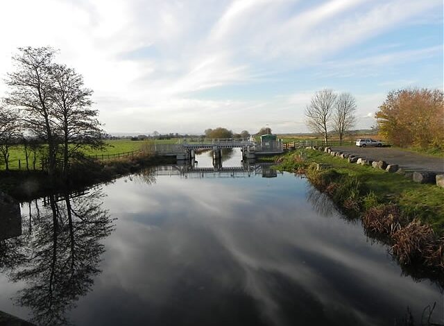
King’s Sedgemoor Drain is a man-made watercourse that has helped shape water management across the Somerset Levels for more than two centuries. Built in the 1790s, the channel carries water associated with the River Cary westward through a landscape where low ground and prolonged rainfall have always made drainage difficult. Its original purpose was closely connected with improving conditions on King’s Sedgemoor, but its role has developed considerably as Somerset’s wider system of rivers, relief channels and flood-control structures has changed.
Today, the drain is best understood as one component of a connected water-management network rather than a standalone flood defence. It works alongside the River Sowy and structures leading toward the River Parrett at Dunball. Major improvement works completed in recent years have increased the capacity of this wider system, while severe weather in January 2026 showed why Somerset still needs several methods of managing flood water. The result is a waterway with both a long history and a continuing practical role.
Why King’s Sedgemoor Drain Was Created
Before large drainage schemes transformed parts of the Somerset Levels, water could remain across the low-lying moors for extended periods. King’s Sedgemoor Drain was constructed between 1791 and 1795 as part of attempts to improve these conditions. Moving water more effectively offered practical benefits for agriculture and land management, but drainage also changed established uses of the moor. Historical opposition connected with grazing interests shows that altering this wet landscape affected people as well as water.
The channel continued to acquire new functions after its original construction. During the Second World War, it was improved to help provide a reserve water supply for the armaments factory at Puriton. Later changes to Somerset’s flood-management network became even more significant. The creation of the River Sowy in the late 1960s and early 1970s linked KSD more closely with a wider system for diverting and carrying flood water across the Levels, giving an 18th-century drain an important place in modern water management.
Where the Drain Fits Into Somerset’s Water Network
King’s Sedgemoor Drain receives water connected with the River Cary around Henley and continues westward across the Somerset Levels toward Dunball. Published distances can differ because sources do not always measure the same thing. Some descriptions refer specifically to the historic artificial drain, official datasets can define a longer water body, and modern flood-management documents may measure the combined River Sowy–KSD route. Treating all of those figures as the length of one identical channel can therefore create unnecessary confusion.
Its destination is easier to understand by looking at the complete network. KSD ultimately forms part of the route through which water reaches the River Parrett near Dunball. The nearby Polden Hills provide a useful geographical reference, while the surrounding moors explain why drainage remains so important. The landscape has relatively little natural fall, so moving large quantities of water efficiently depends on maintaining channels, banks, sluices, weirs and outlets throughout the connected catchment rather than relying on a single structure.
How the Sowy–KSD Flood Route Works

King’s Sedgemoor Drain mainly moves water by gravity, but that description alone does not explain modern flood management. The River Sowy, constructed as the Parrett Flood Relief Channel, allows water to be diverted from the River Parrett through Monk’s Leaze Clyse. From there, water can travel through the Sowy, continue into the KSD system and eventually return to the Parrett through the downstream arrangements at Dunball. This provides another route for managing high flows through the Somerset Levels.
The system is actively managed according to conditions rather than operating as an unlimited bypass. River levels, channel capacity and downstream conditions affect how much water can be moved safely. Pumps can also supplement the wider network during exceptional events, even though KSD itself is fundamentally a gravity drainage channel. This distinction matters because no single drain can guarantee that the Levels will remain dry. The system is designed to reduce and manage flood risk, not eliminate the possibility of flooding during extreme weather.
What Recent Improvements Have Changed
A major programme of improvements has been carried out across the River Sowy–King’s Sedgemoor Drain system. Phase 1 represented approximately £10 million of work intended to improve how effectively flood water could be conveyed through the network. Rather than relying on one large new structure, the programme addressed restrictions at several points. Work included raising selected banks and improving water-control structures and outfalls, with final Phase 1 activity completed during 2025–26.
The practical result is more important than a long list of engineering works. The wider Sowy–KSD system can now safely convey more water than before the programme, with reported capacity increasing from around 17 to 21 cubic metres per second. The Environment Agency has also linked the combined improvements with reduced risk to homes, farmland, roads and railway infrastructure in vulnerable parts of the Levels. These improvements increase resilience, but they do not make the landscape immune to exceptionally severe rainfall.
What the January 2026 Flooding Showed
Severe conditions in January 2026 provided an important demonstration of how the modern network operates under pressure. Following prolonged rainfall and Storm Chandra, water levels across parts of the Somerset Levels and Moors became exceptionally high. Authorities used Monk’s Leaze Clyse to route water through the Sowy and onward through the King’s Sedgemoor Drain system. Additional contingency pumping was also deployed as part of the wider response to the high levels affecting the catchment.
The event showed why flood management in Somerset depends on layers of infrastructure and operational decisions. Improved channels can carry greater flows, but extreme rainfall can still require pumps, temporary equipment and active management of control structures. It would therefore be inaccurate to claim that King’s Sedgemoor Drain prevents flooding. Its value lies in providing an important route through which water can be managed, helping reduce pressure on vulnerable parts of the Levels when conditions allow.
Ecology and Water Quality
Although King’s Sedgemoor Drain was created for practical water management, it now exists within the distinctive wetland environment of the Somerset Levels. Its banks and waters provide habitat for aquatic life and wildlife, but its ecological condition should not be romanticised. The latest classification displayed in Environment Agency catchment information identifies the water body from Henley Sluice to its mouth as artificial and records an overall Moderate ecological status, based on the assessment period shown in that dataset.
Individual indicators reveal a more complicated picture. Fish and some biological measures have faced pressures, while physical modification for drainage and flood protection is itself part of the water body’s environmental context. Nutrient inputs, wastewater, agriculture and oxygen conditions can also influence water quality. Managing KSD consequently involves competing practical requirements: sufficient channel performance for drainage, maintenance of banks and vegetation, and protection or improvement of ecological conditions wherever these objectives can be balanced effectively.
Fishing and Public Access
Fishing is one of the best-known recreational uses of King’s Sedgemoor Drain. The water supports a range of coarse fish, with local angling information recording species such as bream, roach, rudd, perch, pike, tench and carp, along with several smaller species. Different stretches can offer different conditions, which helps explain why KSD has developed a reputation among coarse anglers rather than being known for one particular fish alone.
Access should not be assumed simply because a stretch of water appears reachable from a road or bank. Fishing rights and permissions vary, and club arrangements apply to particular sections. The same caution applies to walking. Drainage banks are operational features and are not automatically public paths along their entire length. Visitors should use recognised access points and public rights of way, respect land-management restrictions and check current fishing permissions before setting out rather than relying on old online descriptions.
Water Levels and the Next Stage of Flood Management
Water levels in King’s Sedgemoor Drain can change considerably after sustained rainfall, so a static measurement in an article has little practical value. Environment Agency monitoring provides current observations at locations including Bradney, while official flood warnings remain the appropriate source during periods of elevated risk. This is particularly important on the Somerset Levels because conditions in connected rivers and moors can influence one another, meaning the appearance of a single stretch does not necessarily represent conditions across the whole catchment.
Attention is also turning to whether additional measures could improve future flood response. For 2026–27, Somerset Rivers Authority is supporting a pre-feasibility study into permanent pumping at Dunball, following the use of high-volume temporary pumps during the January 2026 flooding. A study is not an approved construction project, and permanent pumps should not yet be described as confirmed. Instead, the work represents an investigation into whether additional pumping could complement the existing gravity-based Sowy–KSD system during particularly demanding conditions.
Why King’s Sedgemoor Drain Still Matters
The continuing importance of King’s Sedgemoor Drain comes from its ability to serve a modern purpose despite being created more than two centuries ago. Its function has changed alongside the Somerset Levels themselves: an 18th-century land-drainage project later supported wartime needs, became connected with the 20th-century River Sowy flood-relief system and now forms part of a network undergoing modern flood-resilience improvements. Few parts of the system make sense when considered entirely in isolation.
Its future will likewise depend on management of the wider catchment. Recent engineering works have improved water conveyance, but January 2026 demonstrated the need to prepare for events that place exceptional pressure on drainage infrastructure. At the same time, ecological condition, agriculture, fishing and public access create additional demands around the waterway. KSD remains important not because it can control every flood, but because it continues to provide one of the established routes through which Somerset manages water across a naturally challenging landscape.
Conclusion
King’s Sedgemoor Drain began as an ambitious late-18th-century attempt to improve drainage across King’s Sedgemoor, yet its usefulness has extended far beyond its original purpose. Its connection with the River Cary, River Sowy and River Parrett places it within a network that helps move water across the Somerset Levels. Later modifications and recent investment have allowed this historic channel to continue functioning within a flood-management system very different from the one its original builders knew.
The most recent developments also provide a realistic picture of what flood resilience means. Completed improvements have increased the capacity of the connected Sowy–KSD system, while the severe January 2026 conditions showed that additional intervention may still be necessary during exceptional events. Further options, including the Dunball pumping study, are now being examined. King’s Sedgemoor Drain therefore remains both a piece of Somerset’s drainage history and an active part of how the county continues adapting to water-management challenges.
FAQs
When was King’s Sedgemoor Drain built?
Construction took place between 1791 and 1795 as part of efforts to improve drainage and land management across King’s Sedgemoor.
Where does King’s Sedgemoor Drain flow?
The drain carries water associated with the River Cary westward across the Somerset Levels and forms part of the system that ultimately reaches the River Parrett near Dunball.
How does King’s Sedgemoor Drain help during floods?
It provides a route for moving water through the Levels and works with the River Sowy and associated control structures to help manage high flows and reduce flood risk.
What fish can be found in King’s Sedgemoor Drain?
Recorded coarse fish include bream, roach, rudd, perch, pike, tench and carp, along with several other species. Fishing permission depends on the particular stretch.
Does King’s Sedgemoor Drain use pumps?
The drain fundamentally operates through gravity, but pumps can support the wider flood-management system during severe conditions. Permanent pumping at Dunball is being studied, not currently confirmed as a future project.
You May Also Read: Barrow in Furness Gas Terminal